Weather
Expected Snowfall Amount Increased in Thursday’s Storm
|
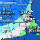
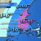
The snowstorm rolling through the area Thursday will be heavier than first thought, according to forecasters. The National Weather Service forecast calls for 8-12 inches of snow, with areas as much as 14 inches, during the storm that will start at in the early hours of Thursday and continue for 24 hours. On Tuesday, the forecast was for 5-7 inches. The snow map produced by WCVB Channel 5, Watertown is in the area forecast to get 10-15 inches of snow. Blizzard conditions are possible during the storm.