STORM WATCH: Monday’s RMUD Meeting Cancelled by Snow

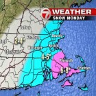
Monday’s storm looks like it could will leave several inches of snow on Watertown, and has closed schools in town, and could have other impacts. The Watertown Public Schools are closed again Monday. The National Weather Service issuing a Winter Storm Warning through 7 a.m. Tuesday. The snow is expected to arrive in Watertown just before 9 a.m., according to Fox25’s weather report. The Boston area could get 6-10 inches in the worst areas around Massachusetts, according to the National Weather Service.

More Snow Coming, Both Monday Commutes Could be Impacted

With tree branches still white from Friday’s storm another bout of snow is forecast to hit the Boston area Monday, and it should be a long one. The National Weather Service has issued a Winter Storm Watch for Eastern Massachusetts and most of Rhode Island from 7 a.m. Monday to 7 a.m. Tuesday. The storm could drop 4-7 inches of snow during that time. The WHDH Channel 7 forecast puts Watertown in the area that will get 4-6 inches of snow. The Cape and Islands will get more snow, and Central and Western Mass.

Check Out These Pretty Snow Storm Photos from Watertown

The daylong storm that hit Watertown Friday left a coating of snow around town, and made for some pretty photos. Watertown News reader April Case sent over some nice shots she took on Friday afternoon. Reader Teddy Kokoros captured this stunning scene along the Charles River after Friday’s snow storm. Len Holt contributed this photo of the winter sunset. Reader Serina Leonard got these shots on Clarendon Street.

Significant Snow Storm Due to Hit Watertown Friday

The National Weather Service has upgraded the amount of snowfall the Boston area will receive Friday, and the area could get 4-6 inches and will impact the morning commute. The storm will hit the South Coast of Massachusetts harder, but the Boston area will also get some snow. Watertown appears to be on the edge of the area under the Winter Storm Watch sent out from the National Weather Service. Rain will turn to snow between 5 a.m. and 10 a.m., so the storm could impact your commute. WHDH Channel 7’s forecast calls for rain and heavy snow from late Thursday night through Friday afternoon.

Get Ready for the Winter’s First Snow Storm, Watertown

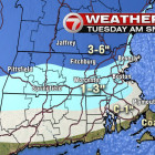
The first significant snowfall of the winter will impact Tuesday morning’s commute. 

The Watertown area will receive more than an inch of snow before it turns to rain. Much of the snowfall will occur overnight, and the storm will change to rain between 9 and 11 a.m., according to the National Weather Service forecast. Snowfall further North and West will be 1-3 inches and the northern part of the state and New Hampshire could get up to 6 inches, according to WHDH Channel 7. The high will be 39 degrees on Tuesday.

Snowy Weather Heading Toward Watertown Sunday

Another several inches of snow could fall on the Watertown area Sunday evening. The National Weather Service issued a Hazardous Weather Outlook for the Boston area. Snow will begin Sunday afternoon and continue overnight, with heavy snowfall at times. The WHDH Channel 7 forecast (see map above) puts Watertown near the line between the areas that will get 2-4 inches and those which will get 4-6 inches of snow. A reminder, Watertown continues to be in a snow emergency, during which on-street parking is prohibited.

Town Fines Property Owner for Creating Snow Dump

The owner of the site where a hotel has been proposed has been fined by the Town of Watertown for setting up a snow storage yard on the property. Trucks have been seen delivering loads of snow to 80 Elm Street, said East End Town Councilor Angeline Kounelis. The snow has been piled so high, she said, that it now is taller than the Watertown Mall, which sits next door. “Doing this is disrespectful to the East End of Watertown,” Kounelis said. “The East End should not be perceived as a dumping ground.”

School Committee Debating Adding an Extra Day of School

All this snow had thrown the school calendar into a bit of chaos, and with the threat of snow still very real Superintendent Jean Fitzgerald has proposed adding an extra day of school. After six snow days, the current last day of school is scheduled to be June 30, but Fitzgerald fears students may get another snow day. The extra day would be on Friday, April 3, which is scheduled to be a day off. “If we had a half day on April 3 and there is no snow the last day will be June 29,” Fitzgerald said. “If we had snow, the last day would be June 30.”