Watertown Declares Snow Emergency, No On-Street Parking During Storm

Effective 6 p.m. on Saturday Jan. 7, the Town of Watertown is under a snow emergency, the Superintendent of Public Works declared. The Watertown Police sent out the following announcement:

On street parking is now banned, any motor vehicle left on the street will be subject to towing. Please assist the public works department by not parking on the street and allowing the public works vehicles full access to clear the streets. We would appreciate your assistance by clearing any snow from fire hydrants and catch basins in your area.

Winter’s First Nor’easter Heading Toward Watertown on Thursday

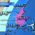
Winter’s first big storm will hit the Boston area on Thursday, with three or more inches of snow forecast for Watertown. 

Snow will fall before 1 p.m., according to the National Weather Service, and will turn to rain. At 5 p.m. it will be a mix of rain and snow. After 11 p.m. the precipitation will turn back to snow. WCVB Channel 5’s early snowfall forecast shows Watertown on the edge of the areas with 1-3 inches and 3-6 inches. The Cape will get less than an inch, while West of Worcester and New Hampshire will get more than 6 inches. Friday’s forecast is for sunny weather with a high of 37 degrees.

Windy Weather in Watertown Today, Frigid Temperatures Friday

Watertown will be hit by windy weather Thursday, followed by bitter cold temperatures on Friday. 

The National Weather Service has issued a High Wind Warning from 5 p.m. on Thursday until 4 a.m. on Friday. Sustained winds will be between 15 and 25 mph, with gusts up to 60 mph. The strongest winds are expected after 8 p.m.

The winds could bring down branches and trees, which could lead to power outages. Be prepared with heating alternatives that do not rely on electricity. The winds, combined with low temperatures will create the possibility of wind chills below zero.

Snow in Watertown’s Forecast, Could Impact Monday’s Commute

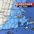
The National Weather Service forecast calls for 1-3 inches of snow in the Boston area, and it could impact the morning commute on Monday. A Winter Weather Advisory has been issued from 7 p.m. Sunday to 1 p.m. Monday. Snow will begin falling Sunday night and will turn to rain Monday morning. There is a possibility of freezing rain during the change from snow to rain, according to the National Weather Service. The low on Sunday will be 26 degrees, but temperatures will rise on Monday with a high in the low 40s.

Expect a Lot of Rain for Over the Next Few Days from Tropical Storm Hermine

While it appears Watertown will not feel the wrath of Hermine, the former hurricane will still have a big impact on the weather this week as it parks off shore. The storm is forecast to stay off the south coast of New England, and rain and thunderstorms are expected to start tonight and last through Wednesday. The National Weather Service (NWS) forecast calls for rain to start after midnight tonight, and showers and possible heavy downpours are expected through Labor Day, with a chance of thunderstorms after 11 a.m.

Winds will not be too strong, with winds 14-18 mph through the next few days and gusts up to 28 mph, according to the NWS forecast. The Cape, Islands and south coast of New England, however, will get some storm impact. In Watertown, the rain and thunderstorms continue Monday night and could continue through about 10 a.m. Tuesday.