Violent Storm Causes Damage, Flooding in Watertown

A short but violent storm rolled through Watertown Tuesday afternoon around 4 p.m., leaving flooded streets, downed trees and other problems.

The storm dumped water at a high rate for about 10 minutes, and also included hail as big as grapes. A number of streets in town were covered in water, including Summer Street at Cozy Street and at Maude Terrance, and Rosdale Avenue. A tree fell on Warren Street near Waverley Avenue and blocked the road. A tree limb fell on a car on Bridge Street near Waltham Street and brought down wires. Wires also fell on Beacon Park, and a tree limb fell on a car on Putnam Street.

Severe Thunderstorm Watch in Watertown on Tuesday

Severe thunderstorms are expected to hit the Watertown area on Tuesday afternoon, according to the National Weather Service. The National Weather Service issued a Severe Thunderstorm Watch Warning on Tuesday, Aug. 4 for most of Eastern Massachusetts, including Watertown. The Warning lasts until 8 p.m.

The severe weather also prompted a Tornado Warning for North Central Middlesex County and Northeastern Worcester County, including Concord, Lowell, Acton and Leominster. The Warning runs until 2:37 p.m.

For more information visit the National Weather Service hazardous weather page.

Tornado Watch in Watertown Tuesday Afternoon and Evening!

Thunderstorms heading toward the Watertown area could be so severe that the National Weather Service has issued a Tornado Watch for Tuesday afternoon and evening. The Tornado Watch is in effect until 11 p.m. Tuesday, and the NWS statement says the mostly likely time for severe weather in Eastern Massachusetts is between 3 p.m. and 8 p.m.

“Isolated wind gusts of 70+ mph or even hail up to the size of golfballs would be a possibility. In addition … an isolated tornado or two may occur,” the NWS statement said. Other possible hazards from the storm include torrential downpours and local flooding.

Snowy Weather Heading Toward Watertown Sunday

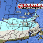
Another several inches of snow could fall on the Watertown area Sunday evening. The National Weather Service issued a Hazardous Weather Outlook for the Boston area. Snow will begin Sunday afternoon and continue overnight, with heavy snowfall at times. The WHDH Channel 7 forecast (see map above) puts Watertown near the line between the areas that will get 2-4 inches and those which will get 4-6 inches of snow. A reminder, Watertown continues to be in a snow emergency, during which on-street parking is prohibited.

See People’s Snow Photos from Around Watertown!

The snow has stopped falling, and there was plenty of it. Share your photos from the Feb. 14-15 blizzard with Watertown News. Above, I think Patti Melanson has captured the feeling of everyone in Watertown these days! Below, the clean up has begun after another dumping of snow on Watertown.

DPW Grabs a Rest as Another Storm Heads Toward Watertown

The Watertown Department of Public Works got a brief rest this week between heavy snow storms, but they will have to go back into action this weekend. 

The National Weather Services has issued a Winter Storm Watch from Saturday at 3 p.m. to Sunday at 7 p.m. Forecasts call for Watertown to get a foot or more of snow, with winds gusting up to 50 mph, according to the NWS. If there is any doubt this is an unusual winter, WCVB reported that Boston set a record for the snowiest February in recorded history. Watertown Public Works Superintendent Gerald Mee got his first night’s sleep on Monday night after being up for 54 hours, and some worked even longer hours. “I haven’t seen anything like this,” Mee said. “The continuous storms and the path of the storms doesn’t appear to be letting up.”