Transportation
MBTA Announces Extra Subway Service for Snow Storm
|
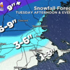
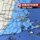
The Massachusetts Department of Transportation (MassDOT) is advising the public that weather forecasters are expecting a winter storm to impact travel across the Commonwealth throughout Tuesday, February 12. Snow is expected to begin falling during the Tuesday morning hours in Western Massachusetts and the storm will move eastward during the day, with snowfall rates at some times of one inch per hour, and with snow changing over to sleet in most regions. Members of the public are advised to minimize travel, use public transportation if possible, consider working from home if that is an option, or consider leaving work early on Tuesday. Driving conditions will become hazardous in Western Massachusetts around 10 a.m., Central Massachusetts around 1 p.m., and in the Boston area and Eastern Massachusetts around 3 p.m.
“We are asking people throughout the Commonwealth to make smart, safe decisions on Tuesday such as taking advantage of public transportation, working from home if possible and leaving early for their afternoon commute,” said Transportation Secretary and CEO Stephanie Pollack. “Everyone should check a weather forecast and travel conditions before heading out to avoid hazardous driving conditions, as there will be varying types of precipitation in all regions of Massachusetts, including snow, sleet, and freezing rain throughout the daytime and evening hours. The MBTA will be running subway lines in the Boston area at increased capacity starting at noon and all motorists should consider leaving early for their commute home and allowing plenty of extra time to travel.”
“MassDOT is currently conducting preparation activities for the deployment of snow and ice crews in advance of Tuesday’s winter weather,” said Highway Administrator Jonathan Gulliver.


