MassDOT
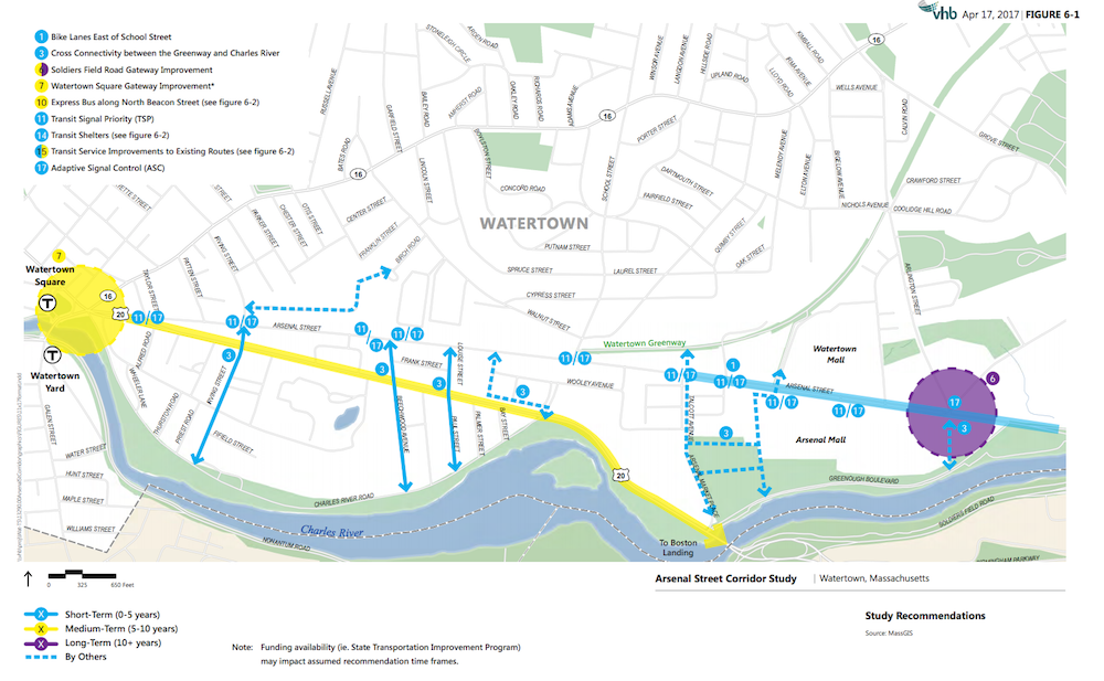
An illustration from MassDOT’s Arsenal Street Corridor Study Draft Final Report showing the locations of the reports recommendations.
The Massachusetts Department of Transportation has released a draft of the report and recommendations for improving the Arsenal Street Corridor, and officials will host a meeting later in June to discuss the report with the public.
The report made for MassDOT by consultants from VHB, includes improvements to vehicular, transit, bicycle, and pedestrian uses of the corridor, “with a targeted focus on enhancements to bus service along Arsenal Street and locations where the bus service ties into other crossing bus routes,” according to the MassDOT announcement. Click here to see the draft Final Report.
The meeting will be held on Thursday, June 22 starting with a presentation at 6 p.m. and an open house from 7 to 8 p.m. The meeting will be in the Watertown Savings Bank Room at the Watertown Free Public Library, 123 Main St.
In the draft final report, MassDOT officials write that the recommendations would require “a significant investment in potential transportation-related infrastructure.”
“These projects represent an investment in total that currently far exceeds available funding as presently programmed. The advancement of the recommendations developed as part of this study will require prioritization by (and coordination between) the Town of Watertown, MBTA, MassDOT, and other stakeholders to address current fiscal constraints as related to transportation improvements,” the draft report reads.
The recommendations listed in the report (with cost estimate):
- Improvements to existing MBTA bus routes ($3.6 million)
- Watertown Square gateway improvements ($950,000 to $1.5 million)
- A North Beacon Street Express Bus to the new Boston Landing Commuter Rail Stop in Allston (variable)
- Bicycle lanes east of School Street ($75,000 to $2.1 million)
- Cross Connectivity between the Watertown Greenway – a.k.a. Community Path – and the Charles River (variable)
- Improvements to the Soldier’s Field Road gateway ($1.5 million to $2.5 million)
- Transit Signal Priority, which gives buses a chance to keep a green light ($250,000 plus the cost of upgrades)
- Adaptive Signal Control ($250,000 to $500,000)
- Bus Shelters ($30,000 per location)
Most of the improvements are proposed to be funded by a mix of state government, local government and private developers. While the improvements to the T service would be paid by the MBTA, a shuttle down North Beacon Street would include a mix of money from the MBTA, members of the Watertown Transportation Management Association (TMA), and other “area stakeholders.”
Improvements to the two main gateways for Arsenal Street – Watertown Square and Soldier’s Field Road – would be paid for with a mix of town funds, developer funds and state transportation funding.
The bike path along Arsenal Street east of School Street could be paid for by a mix of state funds (Chapter 90 and Safe Streets) and developer funds. Because of the width of the road, the bike lanes would not be able to be five feet wide the whole length without making lanes of traffic less than 11 feet wide.
The time frame also varies. Some improvements to the 70/70A bust could take place within 5 years (such as breaking off the 70A loop north of Main Street into its own route), but the study estimates adding new equipment may take up to a decade. Bicycle lanes and bus shelters would be on the short term (2-3 years), but the Soldier’s Field Road and North Beacon Street Shuttle on the long term end (10 years or more). The shuttle could get started as a pilot in about five years, according to the report.
Medium term projects include: Transit signal prioritization (5 years), cross connectivity between the Greenway and Charles River (5 years), adaptive signal control (5 years to get running), Watertown Square improvements (8 years)
For more information about the Arsenal Street Corridor Study, click here www.mass.gov/massdot/
Consider the bike path issue: “The bike path along Arsenal Street east of School Street could be paid for by a mix of state funds (Chapter 90 and Safe Streets) and developer funds. Because of the width of the road, the bike lanes would not be able to be five feet wide the whole length without making lanes of traffic less than 11 feet wide.”
We can encourage bike commuters into North Cambridge via the Community Path and Cambridge Connector. Those going into Brighton need a plan. This minimization of bike path along Arsenal to the East is another reason for utilizing the Rail Road right of way West off of Arsenal St to connect the Community Path down to Watertown Square. It would cross Mt Auburn at Taylor and Baptist Way and connect to the West and river route. Much safer, faster, and roomier for commuters at rush hours and the same for recreationalists the rest of the day. There will have to be some creative negotiating for the land, but nearly all of it is unused and generally unusable by abutters. To connect East and West sections, it would be easy to build a sidewalk level bike path from School Street up Walnut to share some of Doble’s parking lot connecting with the path in the back of Hanover (202 Arsenal) to Greystar at Irving. It is an easy block from Mt Auburn at Irving where there is no bike lane planned going West. This route would then go down the Rail Road right of way almost to the Square. Getting bikes across the river remains problematic. Let’s keep thinking of protecting our bike routes and being sensible–and creative– about shared sidewalks and bike paths without partitions on major commuting streets like Arsenal.