
WorldTech Engineering
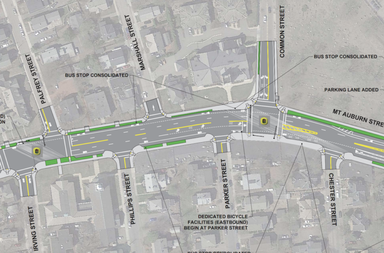
A closeup of part of the Mt. Auburn Street rendering showing the intersections of Mt. Auburn at Irving/Palfrey and Common Street where parking will be removed because it does not meet federal standards.
The following is an open letter from Town Councilor Lisa Feltner to Town officials:
Of the three Mount Auburn Street redesign concepts presented on October 16, 2018 (focus primarily between Patten and Walnut streets), many constituents in District B would like me to reiterate that concept #3 “adds four legal parking spots” to Mount Auburn. Please accept my attempt to summarize many concerns shared with me around this meeting and the concepts presented to date.
Other alternatives and questions to consider, including a fourth and fifth concept follow below: (see plans below, or go to the document page of the project website here.)
Alt concept 4: Modify concept #1 to retain the sheltered Historic District Franklin St. bus, and Russell Ave. bus stops, thereby not reducing MBTA access.
Alt concept 5: Modify concept #2 (which allows 3 parking spaces at Common-Chester) to retain the sheltered Historic District Franklin St. bus, and Russell Ave. bus stops (note: there is a fire hydrant opposite Russell Ave. at Franklin stop). Please note that 7 Chester St. is a c.1886 residential dwelling, with no driveway, used for four apartments and is in front of a fire hydrant.
Adding loading/drop-off or commercial parking to residential streets lowers residential property values and residential sense of place; it also reduces opportunities for handicapped parking. It is common practice to place parking restrictions in high “customer” areas to reduce impacts on residents. It should be noted that there continues to be a growing chorus for a residential parking program, as well as a lift of the winter parking restrictions, given inadequate parking for WPS [Watertown Public Schools], the Senior Center, etc. with increasing need to share the Marshall St. parking lot.
There seems to be a top priority on transit travel times, vs. pedestrian times and destination support, considering that Concepts 1 and 2 reduce bus service in this already activated and Historic District, which is comprised of residents plus small business-church-nonprofit-school-senior-veteran-student-commuter pedestrians. The Comprehensive Plan, updated Zoning, Planning Board and ZBA hearings all speak to further activating our streetscapes, connecting redevelopment to existing neighborhoods, and we justify reduced parking requirements near public transit while needing to support local businesses.
Even with future modernized signals for vehicles and MBTA busses there are concerns about overflow to side streets, especially with projected traffic volumes (e.g. complaints continue RE: Irving Mt. Auburn to N. Beacon). By removing space for a right-turn lane at Parker-Common, backup avoidance will increase traffic on Phillips-Garnet. Also drivers already turn before Parker to avoid backups at Common, so the reduced R[ight] turn onto Common is fueling concern about backups from Common to pressure on Russell-Columbia-Bellevue-Garfield streets.
1_20181016+Alt+Analysis+Posters_Parker+St+District by Charlie Breitrose on Scribd
Summary: Mount Auburn traffic currently backs up from the signals at Parker (toward Irving) and Common (toward Garfield).
There are concerns that the road diet in this section will make it more difficult to back into designated street parking, which encourages circling the neighborhood, parking on residential streets, and discourages customers.
It was presented as a great benefit to build foot and transit connections from the Arsenal St. redevelopments north to the historic neighborhood and destinations on Mount Auburn Street and Watertown Square (Hanover project-Franklin St., and Greystar project-Phillips St.). Redesign concept 1 moves three bus stops further away from established destinations in this Historic District, and it adds load to several non-signalized pedestrian crossings, with its bus consolidation and moves (even as it eliminates “one WHS pedestrian crossing” at signalized Parker, it adds crossings for destinations west toward Square), without revealing some important data and potential improvements. Please consider the following:
1. Is it legally possible to create a loading and/or drop-off zone at the T of Common St., next to the proposed Common/Chester bus stop (moved from Parker), where current parking is removed in design concept #1? (3 spaces are kept here in concepts #2 and #3)
2. Have you identified any handicap only drop-off space?
3. What are the loading needs for current businesses?
4. Is it reasonable to designate loading-only times in some of the street parking?
5. All concept plans show vehicle parking; where is bicycle parking?
6. How do parking changes and bus access at Irving-Palfrey compare to School St. intersection?
7. Will new bus shelter be installed at the proposed Common/Chester bus stop?
8. Will bus shelter be installed at Walnut bus stop? (note: Walnut isn’t shown on concept maps)
9. Will yes R on Red be considered at Walnut?
10. Concept #1 shows the current pedestrian crossing, while removing the sheltered Franklin and the Russell bus stops; will this become a signalized pedestrian crossing? It is not signalized now, but receives higher visibility from the existing bus stops and its historic designation and destinations.
11. Will space for queuing buses be added to Walnut stop?
12. Will the “second” pedestrian crossing at E. Bates/Walnut-west be removed? (Area is not shown on concept maps)
13. How often does 71 Bus bunching occur, or is anticipated, for Historic District stops, such as at Patten, Parker, Franklin, Walnut, Bates E., Russell, Marshall, Summer?
14. Will all signals be coordinated, including with Summer St.? Patten and Palfrey residents are experiencing increased traffic.
15. How much bus travel time is reduced by moving the Parker stop from its current location?
16. How much bus travel time is reduced by removing the Franklin and Russell stops?
17. How much time/distance is increased for pedestrians by removing the Franklin and Russell stops?
18. What pedestrian or bike accidents have occurred with the Parker bus stop in its current location?
19. What are the plans for deliveries or loading on Mt. Auburn? Many use Mt Auburn or side residential streets — they have no parking lots or other delivery access.
20. How might the redesign make is easier for WPD [Watertown Police Department] to enforce proper uses on Mount Auburn?
21. Given the existing on-street parking conditions, there will be a net loss of parking with sidewalk bulb-outs before accounting for “illegal” spaces, even with additional parking created in front of the historic cemetery and in place of the Franklin bus stop, per the concepts presented Oct 16th.
a. What measures are being considered to mitigate additional parking and delivery, drop-off stresses with traffic circulation on side residential streets, for example curbing-sidewalk conditions, bicycle parking and N[orth]-S[outh] connections, trees-green space, one-ways, existing parking restrictions on Marshall, Palfrey, Phillips, and Russell, etc.
b. What outreach methods can be employed to appreciate proposed safety measures and generate excitement for current and potential new uses in this area, especially to support foot-public transit-bike traffic?
Given the longstanding on-street parking conditions along Mount Auburn, it should be recognized that the future means a net loss of parking, even if parking is created in front of the cemetery and substituted for the sheltered Franklin bus stop (where there is a fire hydrant). Safety improvements are welcome and encouraged in all concepts, but we should be fully aware of this reality and transparent with the community about anticipated changes with ongoing communications.
I advocate modifying our parking policies and improving public transit access in support of many of our goals, including successful placemaking and economic development. I have shared my feelings that overall, we are going to experience more inconvenience (disrupt our current patterns), slower travel times (I welcome a lower speed limit), and possibly more congestion, but I anticipate more safety improvements, hopefully a more quiet and pleasant Mount Auburn St. experience for pedestrians and cyclists, and better quality of public transit while supporting local business. It’s a tall order.
Thank you for your continued diligent efforts on this complicated redesign.
Respectfully,
Lisa Feltner
Watertown Town Councillor, District B
My friend who lives in Seattle told me that they prioritized buss and bike traffic in her city. When she was working (she has since retired), it took her one hour to drive three miles. (She had to drive.). That was five years ago. This is the future.
Also, elimination of the winter parking ban would be a mistake. Do people really think folks will find parking for all those extra cars in a snow storm? How many people would not move off the streets? Watertown had better hire very aggressive tow companies. After that, people will ask to allow cars on one side of the street and shovel out a space. That never causes problems.
Sigh – the city known as the Town of Watertown is heading into the problems other cities have yet to solve.