Department of Public Works
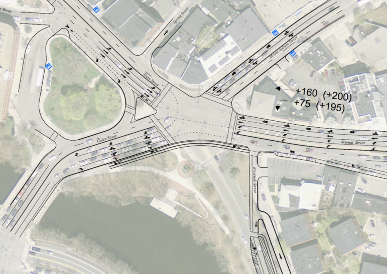
A diagram of what Watertown Square could look like if Charles River Road is removed from the intersection. This shows Option 1.
After taking traffic counts in the area around Watertown Square and along Charles River Road an North Beacon Street, the designers of the Watertown Square Improvement project added more options for how the intersection could be changed.
On July 9, the Town of Watertown held an open house to present the latest options for reconfiguring Watertown Square.
The last time the project was presented to the public, in November 2017, many residents — particularly those living between Charles River Road and North Beacon Street — opposed the idea of removing Charles River Road from the Watertown Square intersection. Representatives from the Town’s consultant on the project, VHB, said traffic counts would be done before coming back with recommendations for the project.
“Based on the traffic counts, rather than reduce the options, we added more,” said Dennis Sheehan, the DPW’s Director of Administration and Finance. “If one solution would have clearly worked best we would have presented less options.”
In November, the Department of Public Works and VHB presented four options for Watertown Square, and when they came back last week there were six options. The two new additions keep Charles River Road in the main intersection.
The goals of the project include not only improving traffic flow through Watertown Square, but also improving conditions for pedestrians, cyclists and public transportation users. Also, some options create additional open space near the Charles River.
The traffic counts looked at the neighborhoods between Charles River Road and North Beacon Street, which would be impacted by the removal of Charles River Road from the Square.
Laura Castelli from VHB said the majority of the traffic on Charles River Road, about 300 vehicles, goes eastbound away from the Square on weekday mornings, and heads west toward the Square in the evening rush. The survey also showed that Charles River Road was slightly faster that North Beacon Street in the morning rush, and significantly faster in the evening rush, heading toward the Square. See traffic counts and maps by clicking here.
Many residents at last week’s meeting remained skeptical of the idea of removing Charles River Road. Even those who don’t live in the area say they like to have to option of that roadway.
See some of the differences of the six options below:

Department of Public Works
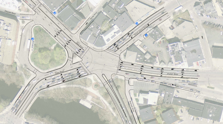
A diagram of Option 6 for the Watertown Square redesign. This option essentially keeps the current configuration of the Square, but adds a second left turn lane from Arsenal Street onto Galen Street.
Charles River Road
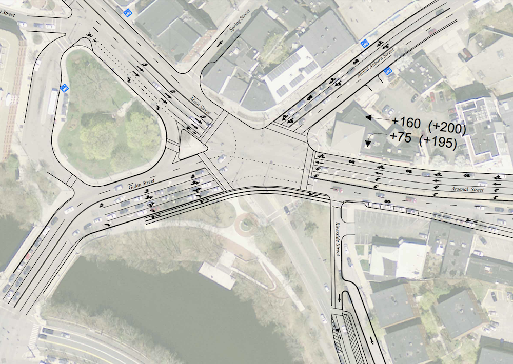
Options 1-4 would remove Charles River Road from the Watertown Square, leaving four roads leading to the intersection. Options 5 and 6 keep Charles River Road flowing in and out of the Watertown Square intersection.
In Options 1-4, Charles River Road would intersect with North Beacon Street just east of the Square, but there are differences in directions of the roadway. Also, Riverside Street would be linked to Charles River Road in these options.
In Option 1, Charles River Road is one way heading east (away from the Square) until Wheeler Lane, where the roadway turns into a two-way street. In this option, Riverside Street would be linked to Charles River Road, and drivers would have the option of going east on Riverside Street.
Option 2 has Charles River Road becoming one way eastbound the entire length of the roadway. Riverside Street would also be linked to to Charles River Road in this option heading east.
In Option 3, Charles River Road would be one way westbound (toward the Square) from Wheeler Road west. Riverside Street would be linked to Charles River Road, and would be available as a two-way road.
Option 4 keeps Charles River Road as a two-way road for the entire length. When it hits North Beacon Street, drivers will only be able to go right. Riverside Street links to Charles River Road and would only go eastbound.
Traffic Flow
In Options 1-4, designers estimate the delay for vehicles traveling through Watertown Square would be reduced between 15 and 40 seconds per vehicle.
For Option 5, the amount of time it takes to get through Watertown Square would increase by 15 seconds during the morning peak hour.
The time it takes to get through the Square would be reduced by 20 seconds in Option 6.
Lane Configuration
The lanes for each branch coming into Watertown Square change in some of the options. Options 1-5 would change how Galen Street comes into Watertown Square, and would help avoid having backups of cars trying to go straight from the inner left-turn lane. In this configuration, there would be a left turn only lane, with a left/straight lane next to it, then a straight/right lane and on the right side, a right-only lane. Option 6 keeps the current configuration, with the two left-only lanes..
In order to do this, the traffic patterns would change. Currently, the left turns in facing roads go, then the straight traffic goes. To allow the new configuration, all traffic from one branch will go at once before switching to the next one.
Options 1-5 would continue the two-lane configuration of Mt. Auburn Street heading south into the square. In Option 6, a third lane is added to create a left turn lane, with a straight-only lane in the middle and a straight/right-turn lane on the right.
All six options call for having two left-turn lanes from Arsenal Street onto Galen Street. Also, all options have four lanes on Main Street heading east into the Square, with a right only heading toward Galen Street, two straight only lanes in the middle and a left turn lane on the left.
Pedestrian Crossings

Department of Public Works
Some of the options for redesigning Watertown Square would decrease the amount of time it takes to cross streets in Watertown Square.
Options 1 through 4 would reduce the time it takes to legally cross Arsenal Street/North Beacon Street and Mt. Auburn Street. Currently it takes 200 seconds to get from the west side of Mt. Auburn Street to the south side of Charles River Road crossing with the walk signals.
The changes in lane configurations and removal of Charles River Road from the intersection in Options 1-4 would shorten the time waiting for “walk” signals at these intersections to 80-90 seconds.
There would be no change in the crossing times for Options 5 and 6.
Bicycle Accommodations
In Options 1-4, the redesign could allow for bicycle lanes on some roadways leading into Watertown Square.
Options 5 and 6 only allow for bicycle accommodations on Main Street.
Public Transit
Options 1-4 allow for the Watertown Square bus stop for the 70 bus eastbound to be moved closer to where the 71 bus stops on the Watertown Delta.
The stop could not be moved in Options 5 and 6.
Open Space
Options 1-4 would create 15,000 sq. ft. of new open space in the area where Charles River Road now intersects with Watertown Square. In Option 2, where Charles River Road is changed to a one-way road eastbound, there are additional opportunities to create open space and recreational opportunities.
There would be no additional open space in Options 5 and 6.
See the documents and more information about the Watertown Square redesign project at the project website: https://watertownsquareimprovements.com/documents/
Residents Worry About Impact of Changes to Watertown Square, Charles River Road

I would like to see either an overhead or under ground walk/bikeway that can get someone from the alleyway next to CVS over to the Charles River pathway.
Thereby avoiding the intersection altogether. Traffic would be vastly faster for everyone!
I don’t see any comments on how they are going to mitigate all the additional cars that will be turning from Arsenal St onto Galen St by adding a second left turn lane. Vehicles frequently backup into the intersection already coming the Mt Auburn St onto Galen St, now there will be even more?
Not much improvement here. Your still taking your life in your hands crossing from Main St CV to the mbta Depot on Galen St which is ugly & disfuntional.
Anyone thought of tunnels? Make Watertown Sq a traffic free zone and a gathering place for people. Let’s be creative, perhaps starting with a strict limit on growth & traffic. We need a solution not Plans that are less pathetic than the next.
Bruce, I like your idea of tunneling the car traffic under the area but having to do it for 4 directions and being in close proximity to the river probably makes that impractical. A tunnel or overpass for pedestrians & bikers, in MHO is doable.
A Y design is what I have in mind. Going from CVS area to either side of the Charles River bridge.
No need for the buttons to slow traffic for each pedestrian. Pedestrians would not have to stop and wait. Win win.
If I read this article correctly drivers can expect to save 15- 40 seconds going through Watertown square during peak traffic hours, and depending on the solution selected it may or may not improve conditions for pedestrians, cyclists and public transportation users.
I just cannot fathom anyone spending such a large sum of money (the amount needs to be determined but it must be very large) for these results.
Please provide input if I misread this article!
Say 50,000 cars go through a day saving an average of 30 seconds. That is over 400 hours saved per day of people’s time.
Yes, but it is at most one minute (30 seconds each way) a day per person, which is still a HUGE amount of money and aggravation for such a little saving of time per person. A better, more in depth traffic study including ALL streets that are effect really needs to be done before Major changes are approved and money is invested.