Public Weighed-in on Proposal at Thursday’s Meeting, No Vote Taken
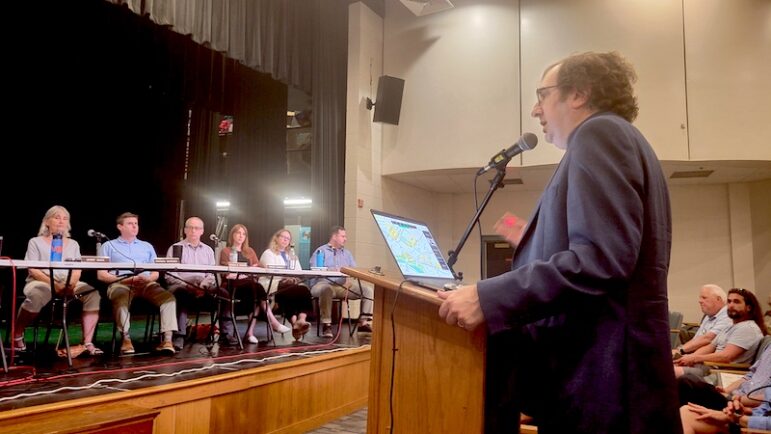
City officials presented the latest draft of the Watertown Square Area Plan to the public on Thursday night, but the City Council and Planning Board did not take a vote on the proposal. They will reconvene in two weeks to continue discussing the report.
At the meeting held at Watertown Middle School, City Manager George Proakis said even when the draft is approved, it will not be the end of the process. Rather, he paraphrased a Winston Churchill quote from World War II,
“I actually think we are at the end of the beginning of this process by handing you over a plan,” Proakis said. “Should you see fit to pass this plan and should we say OK, we’re gonna go forward with this. This is not the last public hearing on Watertown Square.”
The ideas in the plan must be encoded in the City’s zoning, and those changes will come back to the City Council and Planning Board in a public hearing before the zoning changes are approved, Proakis said. More meetings will be needed to refine the streetscape designs proposed in the plan, as well.
Other parts of the plan, such as the realigning of roads, need to be studied further, Proakis said.
“We would take this from design to deeper engineering,” he said. “We would have traffic through and around the neighborhoods looked at and studied carefully to determine if we should shift the streets or make additional changes, or how would you make that happen – all with more public process and conversation.”
City Council President Mark Sideris said the discussion of the plan will continue in two weeks, on Thursday, June 27 at 6 p.m. at the Middle School. That night, the City Council and Planning Board will have a chance to have a more in depth discussion of the plan. Whether a vote is taken that night, he said, is not certain. After the boards have their discussion on the 27th, the public will be able to comment.
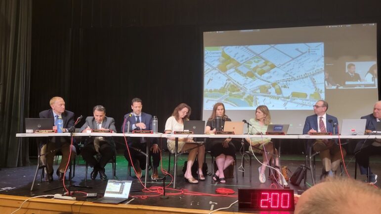
On Thursday, the focus was hearing from the public about the draft plan. About 60 people commented in person, remotely, or by email.
A large group of people supported the plan, with some preferring to see even more housing than the 3,133 unit capacity (number of units possible in the by-right housing zones) proposed in the draft plan.
A significant number of people spoke out against parts of the project, including preferring to stick to the minimum unit capacity required in the state’s MBTA Communities Law, which for Watertown is 1,701. Others said they believe the 6.5 stories allowed in parts of the plan is too tall for Watertown.
Several people said they would like to see more affordable housing created in the zoning, with some calling for an increase of the bonus for projects that have a “substantial amount” of affordable housing from one additional story to two.
Others worried about the traffic created by the increased number of housing units in Watertown Square, and with the number of lanes being reduced in the main intersection in the square.
The plan allows for minimum parking of 0.5 spaces per unit in the by-right areas. Some residents said they worried that people would end up parking on neighborhood streets.
Improving public transit was raised by multiple people, with some calling for a dedicated bus lane from the Watertown Yard, across the Galen Street Bridge, and through the Square.
Multiple residents said they would like to see better communication from the City about the plan and the meetings, with one resident suggesting a postcard be sent to all residents before the next meeting. Proakis said that he is not sure that the post cards would arrive before the next meeting, because of the time it would take to create the post card along with the time for the Post Office tp deliver them, which can be up to 10 days.
Others wanted to have more polling of residents about the plan, and wanted details of how the polling and surveys that have already been conducted in the process.
Housing
The housing portion of the draft plan looked similar to the plan proposed at the April 4 meeting.
“We’re concentrating higher density areas toward the center of Watertown Square with commercial development, and then we want to activate uses in the center,” said Loren Rapport, from design consultant Utile. “And then we have lower density zones that transition to smaller scale residential areas.”
The unit capacity of 3,133 and the area of by-right multifamily housing remained the same, with the rest of the study area allowing multifamily housing with a special permit. In the latter, projects would require approval from the Zoning Board of Appeals, which can place conditions on the approval (while in by-right areas there would be no special permit required).
“We think special permit zoning is important for the rest of the study area, particularly on sites that are more sensitive to redevelopment and use,” Rapport said. “… We also think special permit parcels are appropriate for areas that abut lower density residential districts.”
Some spots in Watertown Square, such as the Watertown Savings Bank main branch, would also require a special permit because the architecture adds to the character of the Square, Rapport said.
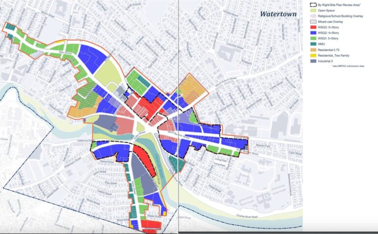
A new addition is the Neighborhood Mixed Use (NMU) zones, which was placed along the westside of Galen Street, as well as at the far end of the study area on Main Street and in a section south of Riverside Street (shown in the teal areas in the map above). The NMU would have 2.5 stories, rather than the 3.5 stories or more allowed in other zones in the Watertown Square Area zoning.
Some residents said that they would like to see taller buildings allowed along Galen because it is near the Watertown Yard bus hub.
The Intersection
As with the April meeting, the draft includes the Four Corners proposal to redesign the Watertown Square intersection.
Highlights of the plan include using the existing bus turnaround area on the Delta to allow cars heading toward Galen Street from Main or Pleasant Street to avoid the main intersection, and it also removes a road from the intersection, said urban planner Jeff Speck.
“Charles River Road, which turns the intersection into essentially a starfish shape, and the fact that all of these streets come together in one place means that the light cycle has to have many phases,” Speck said. “And that means it’s a very long line, which means it needs a lot of what we call storage.”
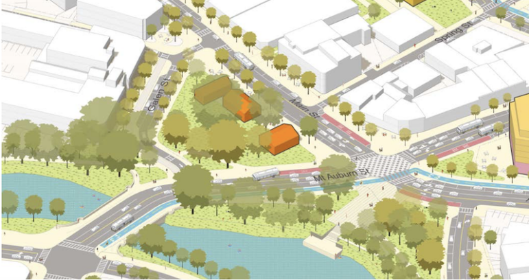
Charles River Road would be moved east to hit Arsenal Street in a T intersection, where it would be a right-only turn. Traffic from that area heading west (toward the main intersection) would use Irving Street to turn left.
The number of lanes would be reduced to three at most in Watertown Square, Speck said, which would create 156,000 sq. ft. of new open space.
“The net gain is over three acres of new open space. That’s important. What I think more important is the way the traffic will be calmed, and much easier to cross and much more civilized as a result of this organization,” Speck said.
Some of the new open space would be on the Delta in Watertown Square, where the plan recommends having pavilions where small businesses could be located, and possibly become incubator space for new businesses, Speck said.
There will also be more street parking, said Ralph DeNisco, a traffic engineer from Stantec.
“Many of these streets, now we’re showing with curbside parking in places where there isn’t today,” DeNisco said. “And that really has a great benefit to the parking supply and the Square potential activation of the retail spaces, as well as just the feeling of safety as you’re walking on the streets.”
The plan also has bike lanes extending down Arsenal Street from where it ends now at Irving Street and continuing east across Mt. Auburn Street at Baptist Walk where it would connect to the Community Path behind the Watertown Library. Also, it would connect to paths on the river at Watertown Square.
Redevelopment of the Municipal Lots
An area discussed in more detail on Thursday was the potential redevelopment of the municipal parking lots behind CVS and behind the Library. The plan also shows using privately owned parcels, including the lot behind the former Santander Bank, and the commercial building on Church Street that is home to a diner, a hairdresser and a laundromat.
The redevelopment could have a parking garage as well as residential buildings on the site.
The draft proposes that the City create a redevelopment authority, which allows the City to work with private landowners in a public/private partnership, Proakis said, which would not be allowed otherwise under state law.
“If the Council and Planning Board were to see fit to do this, that would allow us to enter into the types of developer partnerships with community process and shared solutions where we can work with existing landowners and find solutions and make this kind of work together, if that makes sense,” Proakis said.
Other Redevelopment Opportunities
Proakis also pointed out other areas which could provide special opportunities for redevelopment, including the former Police Station, the former Belmont-Watertown United Methodist Church, and part of the MBTA’s Watertown Yard.
The old Police Station, on Whooley Way, sits next to the Watertown Free Public Library, and could be a place to expand the library, Proakis said.
The former Methodist Church on Mt. Auburn Street could become a site for affordable housing or some combination of affordable housing and public space, he said.
The MBTA has proposed redeveloping part of the Watertown Yard, on Galen Street.
“They have been back and forth looking at possibilities for the site for a long time,” Proakis said. “For a while they talked about it as a lab building site. The plan suggests we think it’s a good kind of six story housing site, as well as serving the buses, bus yard turnaround — all the things that need to happen there.”
See the draft of the Watertown Square Area Plan by clicking here. Find out more at the Watertown Square Area Plan website, watertownsquareimprovements.com.
Hello City Councilors,
I would like to go on the record with a few comments and questions on the plan presented last Thursday 6/13/24.
First, I commend the new design–lots of thoughtfulness and innovative thinking went into it. I am happy to see more housing built. Also the public process has been excellent. Thank you for all the hard work.
Here are a few things that bother me:
1. Will someone please tell me why setting back the top floor of a 5- or 6-story building matters? It’s all about the experience on the street, and that is not about height, it is about mass. Setting back the top floor of the taller buildings will have NO impact on the street experience. Ditto changing the shape of the roof. Every time I hear this, I think someone is scamming me!
2. Likewise, changing the articulation of the building facades by minimally indenting parts and using multiple colors is pretty lame to the street experience. It helps somewhat, but not to the extent that I would call it “mitigation”. (More on this below)
3. Please change the designation for the parcel on Nonantum Rd, along the river. Allowing a 5+story building there is an insult to the river, our most wonderful asset. For those who paddle, fish, walk or otherwise use that area near the dock, a tall building there will completely ruin it. Please do not put tall buildings that close to the river. We already have the eyesore of the Galen St lab building—at least that is farther back.
4. Living on Bay St along Charles River Road, I think the changes to Charles River Road will work as long as the road remains 2 ways for most of it and as long as some thoughtfulness goes into planning for increased traffic on cut-through streets, esp. Irving and Riverside. We in this neighborhood need to know how the impacts of this change will be mitigated so we do not end up with crazy, lost drivers desperately trying to get out of the neighborhood to get to the Square or back on N. Beacon. What kind of signage will be added to discourage people from taking a left onto CRR from the back of the Arsenal Office Park? What kind of mitigation will be done for then increased traffic on N. Beacon St? (people live there too). I would hate to see that street become a highway that is impossible to cross. Really need to think of the consequences here.
There were some great comments at that meeting that I would like to second (I’m paraphrasing):
1. “State government demands on MBTA communities should work both ways”. If they want to add housing (a commendable idea), they should reciprocate with better MBTA service to those communities. Watertown is especially in need of better service. Do we have any leverage here?
2. “People in this new housing without cars will need to buy food.” For years, we have been promised a grocery store in almost every new development that has retail. No one in the town’s planning dept has ever followed through with making sure that the retail spaces created will have any use besides a nail salon:)(no offense to nail salons). These spaces along developments on Arsenal and Pleasant have as a result remained empty and useless. This time, can we plan for a Trader Joe’s in the Square? I say TJ because it is an affordable grocery store that is not as large as a traditional supermarket, and lots cheaper than a Roche Bros.
3. “Needs more thoughtful green space.” Yes! There is a net gain of green space, mostly along the river, but the streetscape needs lots more. Rooftop gardens are good for rooftops. Larger setbacks to buildings, or bigger indents that include seating and green space (and trees!) will do a lot to make the space walkable.
Please consider the Arsenal Mall. Go up and walk around there as you are considering this plan. It’s a nightmare to drive into (which may be a good thing), but you will see a vibrant walking area that is used by families, kids, people with dogs, etc. Isn’t that what we want for Watertown Square? I am honestly surprised at how successful this development is and eat my initial doubts.
Ask yourselves why it is so accessible and friendly? Then look at the height of the buildings around it (they are tall!). Obviously, the height of the buildings is not scaring people away.
I believe that this development captured some basic truths about walkability: You don’t even notice the heights of the buildings when you are walking around. Why? Because there are cut-throughs and setbacks (open squares) that allow for a varied experience walking around—on the ground. You are never caught walking along a mass of a building in order to change direction or get to the next block (why articulated facades don’t work). It is also so much more interesting to look at and sit. There are places like Bond Sq that have ample space to unobtrusively sit and hang out without breathing in gas exhaust. The public spaces actually create private cubbies. I have seen this also used on some buildings in Boston. Anytime there is a cut-through where you can see behind or a distance, that makes the feel of a place cozier.
Some other buildings to consider:
1. Elan Union (Arsenal and Irving): You can cut through this building along the street facade and there are large squares interspersed with 4+stories. This was the first building to use the Design Guidelines and it shows. Also, It is not that deep, so walking behind it to get to Mt. Auburn or the neighborhood behind is not ugly or taxing. (Compare this with the Gables down the street. A huge mass of a building that no one walks around, even with a park hidden in the back. Please no gated communities!) The only part that fails is along Irving Street where it is just a big mass. The park across Irving St — wait — is that actually a park or a picnic area stolen from a highway exit?
2. 345 Harrison Avenue. A large apartment complex (6+!) with a square in the middle and cut-throughs from Harrison to Traveler and Washington Sts. Go walk there. You don’t even notice the building heights. And the facade articulation isn’t just cheap color changes, it’s actually architecture!
3. Lastly, one of the better-loved buildings in Boston: Rowes Wharf. Imagine what a difference not having that open arch would make?
While I realize that form-based zoning cannot be too specific, I would hope that you can somehow get rules in there that would encourage good and thoughtful architecture. There is no reason why developers can’t make just as much money off a well-designed building with truly public spaces. If you want Watertown Square to be a vibrant public space, it takes good, thoughtful design.
Thank you for sticking with me here,
Marcia Ciro
13 Bay St
This is a series of wicked awesome reflections! It is urbanesque rather than small prairie town-like, which is what some are advocating for because they think Watertown is a suburb. It’s an innercore city which you recognize when you look to Boston for ideas. I would love an arch! The Waterfront from Rowes Wharf to the Court Building is a great walk!
Actually Watertown is not urban core. It is a classic example of what is called a “street car suburb”. It is second ring at best.
The development of the Watertown that we know today began when the street cars running along Mount Auburn Street were electrified in 1912. Prior to that, Watertown was primarily agrarian with over 100 working farms. The farms were then subdivided and most of our legacy housing stock was built before WWII.
Until recently we had the descendants of those street cars in our electrified trackless trolleys.
I live on what was once the original Kimball farm. Kimball Road is where the Kimballs had their farm house. The Watertown Free Public Library has a picture of it.
I was at the meeting. I haven’t watched the video yet. I agree with your friend about the constant interruptions from the audience. And 100% the City Council President should bring his gavel and do a three strikes and you’re out! This is an excellent idea! I also like your thought on the other things that occur. I don’t think the city can do anything about propaganda or disinformation, but I think you’re right about the misinformation regarding the capacity for 3331 units and not the building of 3331 units. I know I went up to correct that point. Though it may have had more gravitas if it came from the City Manager. Great idea!
Sometimes, people make comments to, specific, nonexistent statements. Thanks to WCA-TV, most meetings in Watertown are archived for posterity. My verbatim statement at the 06/13/2024 Joint Meeting of the City Council and Planning Board, to discuss the Watertown Square Area Plan, was as follows:
http://vodwcatv.org/CablecastPublicSite/show/3238?site=3
“Thank you so much for giving the community the opportunity to participate in this process. So many of us have seen the growth in Watertown. It’s not an easy process. And certainly, we know the devil is in the details.”
“We’re looking at massive changes here in Watertown Square that will impact not only the Square, but the entire community. We’re speaking about density. We’re speaking about traffic and congestion. We’re speaking about infrastructure.”
“I’ve followed some of the other communities that are impacted by the MBTA Communities Act. Many of them are speaking about the infrastructure and how it relates to their communities.”
“I look at page 49 of the project [plan] and there are only three paragraphs that speak about infrastructure. And I quote: “..will require substantial infrastructure improvements”. And it goes on, and on, about how $1.8 million has been set aside. Talks about relocation of utilities; creation of street grid, etc.; Community Paths; while working around the City of Cambridge water supply [line]”.
“Many who have been involved know about the previous garage structure that was proposed for the Watertown Square area. And how it was found to be not feasible. As I said before: the devil is in the details.”
“So, we are looking at a concept plan, here. But, we are voting on, or will be voting on, finite decisions; zoning decisions.”
“Too many issues here to take into one cohesive plan. There’s the MBTA Communities Act, and there’s zoning. I think there should be separate votes taken on some of these issues. Thank you.”
Best,
Angie
Angeline Maria B. Kounelis
Retired District A, East End, City Councilor