WorldTech Engineering
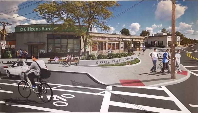
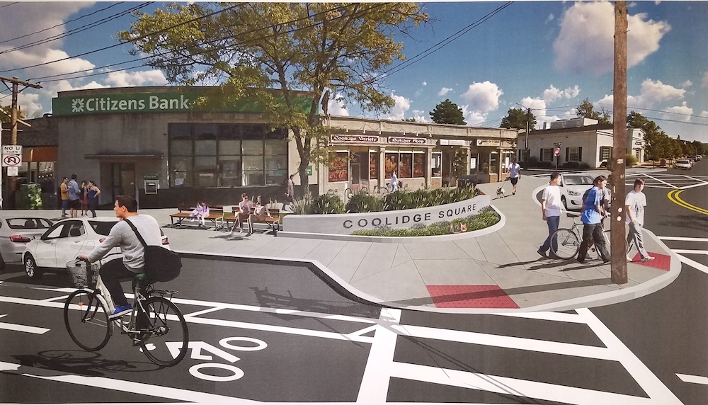
A concept of what a new bump out area at the corner of Mt. Auburn Street and Bigelow Avenue could look like. It is part of the planned Mt. Auburn Street Project.
A Town Council subcommittee recommended some significant changes to Mt. Auburn Street, including a redesign of one of the main intersections in Coolidge Square.
Tuesday night, the Public Works Committee discussed the proposed changes to Mt. Auburn Street, east of School Street. The most significant change is the realignment of the intersection of Bigelow Avenue with Mt. Auburn Street, which also turns Kimball Road into a one-way street away from Mt. Auburn (but only to the first driveway).
The meeting was the second one reviewing the proposals from designers to redesign Mt. Auburn Street. The proposal also puts a new light at the intersection of Arlington Street and Grove Street, and the driveway to Tufts Health Plan on Grove Street would be part of the intersection.
Bigelow Avenue/Kimball Road
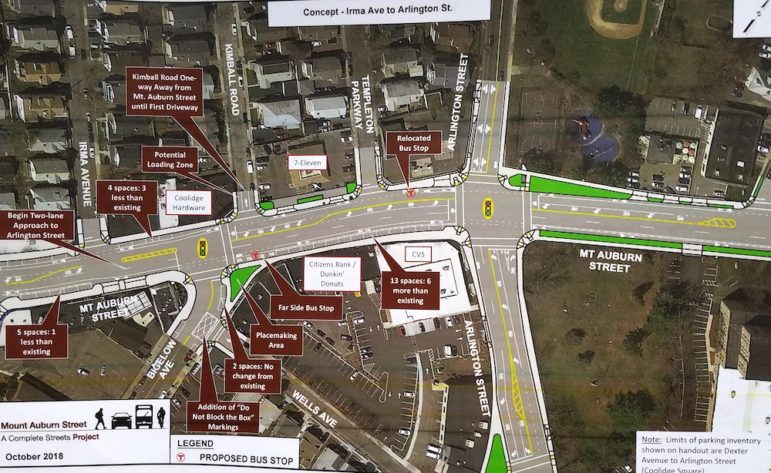
The committee looked at three options. Two called for removing the small triangle on Bigelow at Mt. Auburn and put in a larger pedestrian area on the corner in front of Citizens Bank. Also, both would change Kimball Road into one way away from Mt. Auburn to the first driveway. That means drivers could access Kimball from Maplewood heading toward Mt. Auburn, but would have to stop before getting to Mt. Auburn Street.
The third option kept the current configuration.
In the first two options, there would also be no left turn from Mt. Auburn Street eastbound onto Kimball. This was done because drivers would have to cross two lanes of traffic, which would be stopped at certain points because the stop line will be moved from the east side of Kimball to the west side.
The difference between options 1 and 2 are the placement of the bus stop. In the first, it would remain where it is, in front of the Deluxe Town Diner. While in the second, the stop moves east of Bigelow, where the new pedestrian bump out is located. If the bus stop is east of Bigelow, as in option 2, it also allows for the traffic lights to be part of a Traffic Signal Priority system that allows buses to get through the traffic light faster, said Kris Surette of WorldTech Engineering, the firm designing the project.
Option 1 created six new parking spaces, while Option 2 created three, for a total of 43 in the Coolidge Square area, Surette said.
Some worried that the new bus stop in Option 2 would create an attractive area for people running into Dunkin’ Donuts to “stop for a minute.” Others suggested that if that happens, police should ticket the drivers, and word will get out.

WorldTech Engineering
A diagram showing some of the recommended changes to Coolidge Square, including changing the configuration of Bigelow Avenue at Mt. Auburn (adding a bump out and moving the bus stop) and making Kimball Road one way away from Mt. Auburn Street.
Business Concerns
The section of Mt. Auburn Street Coolidge Square features several restaurants, a number of markets, plus an always busy Dunkin’ Donuts. Many of these establishments do not have an area for trucks to make deliveries.
Most of the Coolidge Square area would be reduced to one lane each way, except eastbound from Bigelow Avenue to Prentiss Street. Mal Atamian, who owns Mt. Auburn Grill in Coolidge Square, said he can get deliveries in the back, but worries about others.
“How will all the restaurants get deliveries,” said Atamian, who added that he worries that trucks will stop on Mt. Auburn Street and block traffic.
Surette said there are some options that could be used, including designating certain parking spaces as loading areas during certain hours, such as 6 to 9 a.m. or 7 to 9 a.m.
“We have also identified side streets as places were we could have space to park trucks,” Surette said. “Also, they could encroach into bike lanes and still allow the flow of traffic.”
Town Engineer Matt Shuman said that the bike lanes will still be available most of the day.
“We are not trying to ignore issues of bikes and bike safety,” Shuman said.
Bicycle & Pedestrian Committee member Andy Compagna said that bike lanes being used for loading zones goes against bike safety, because it forces cyclists to move into traffic to get around the trucks.

Charlie Breitrose
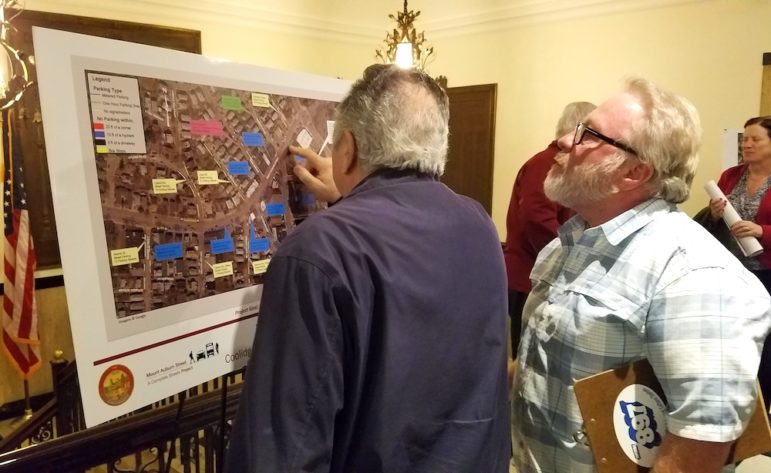
Residents look at proposed changes to Coolidge Square that would be part of the renovation of Mt. Auburn Street.
Traffic
A number of residents questioned why Mt. Auburn Street was being changed so drastically, from two lanes each way to one way. Especially as traffic studies show traffic will increase by 5 percent by 2040.
“With traffic increasing, you are decreasing the (lanes),” Atamian said. “Leave Coolidge Square alone.”
He suggested reducing the speed in the area, but keeping two lanes and letting bikes share the lanes.
While the “road diet” reduces travel lanes on most of the roads, left turn lanes are added at key intersections to allow traffic to flow, designers said. The goal of the project is to accommodate all forms of transportation on Mt. Auburn Street, said Town Council Vice President Vincent Priccirilli (who chairs the Public Works Committee), including motor vehicles, public transportation, bicycles, and pedestrians.
Plan to Redesign Mt. Auburn St., Common St. Area Creates Parking But Not In Front of Stores
The Town is seeking to have the project funded by the state through the Transportation Improvement Program, or TIP. The project is on the Massachusetts Department of Transportation’s list of priority projects.
East End Town Councilor Angeline Kounelis said she worries about the backup of traffic. She has seen the traffic backups already in her neighborhood, off Mt. Auburn Street east of Arlington Street, and worries it could get worse.
“How it is configured now with one lane west, people waiting to go left from Mt. Auburn Street onto Arlington backs up to Prentiss Street,” Kounelis said. “From my street, Keenan Street, you can’t make a left to go east on Mt. Auburn Street.”
Next Steps
The Public Works Committee voted to recommend the Town Council adopt the proposed changes to Mt. Auburn Street, including option 2 (putting in the bump out on Bigelow Avenue, moving the bus stop east, and making Kimball Road one way at Mt. Auburn Street).
Town Councilor Tony Palomba said he liked option 2 because it added some parking and improved public transportation. Woodland agreed that option 2 provided the most improvements.
Now the recommendations from this meeting, and the one on Oct. 16 (which covered the area west of School Street and focused on the Common Street area) will go to the full Town Council to get approval, Picccirilli said.
Once the Council gives its OK, designers would then complete the 25 percent designs, which would be submitted to MassDOT for comment, said Rick Benevento, President of WorldTech Engineering. He expects the designs to be submitted by February 2019.
After MassDOT officials look at the designs, they will release comments on the project. Piccirilli said that the Public Works will hold meetings after getting comments from MassDOT, as well as to review comments from the public during the Oct. 16 and Oct. 30 meetings. Designers will work with MassDOT to deal with any concerns they have.
Once that is finished, MassDOT will hold a meeting in Watertown to get public comments. Benevento said that could occur in the summer of 2019.

Having just one lane west bound with no cut into the sidewalk area for the bus to pull over will impede the flow of traffic.
Please incorporate more seating in the area marked as holding areas.
Please don’t show them as green since this will make them seem like it’s designated as green areas.
Additional parking should be made in front of the basket ball court.
Given the controversy, magnitude, scope, permanence and negative impact this project will have on our community, I believe it is imperative that residents have a greater say in this matter. With that in mind I would propose that the issue be decided by the residents and voters in our community via a local ballot initiative/public policy petition.
From previous meetings I attended, this disaster in the making is planned for construction sometime in 2022, making the 2020 general elections an ideal time and opportunity to this to rest once and for all.
Lets make this happen!
Charlie would it be possible to attach the image or plans for the sections Councilor Feltner is referring to in her letter? The visual would be very useful in reviewing her thoughtful comments. Thank you, Elodia
Sure. I added some documents and a link to the project site.