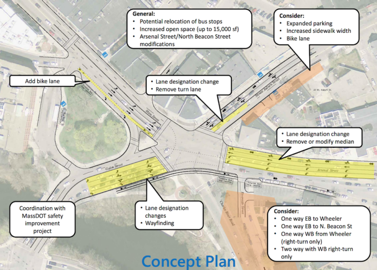
Some of the proposed improvements to Watertown Square.
Residents living between the Charles River and North Beacon Street, east of Watertown Square, packed the Town Council Chambers well past seating capacity Tuesday night because they are concerned about traffic near their homes and how the area could be impacted by the Watertown Square Improvement project.
A study of the Arsenal Street corridor for the Massachusetts Department of Transportation (MassDOT) by consultants from VHB identified several improvements that could positively impact the major artery through the east side of Watertown.
VHB’s Laura Castelli said that residents who attended public meetings about the Arsenal Street Corridor study overwhelmingly supported making improvements to Watertown Square the top priority.
One major change proposed to improve flow through Watertown Square would be to remove Charles River Road from the mix, at least in one direction (in or out).
The project was originally scheduled for the medium term, Castelli said, because it was thought the town would have to wait to get state road improvement funds, but it was pushed forward because it will be part of the I-Cubed project. This is an joint agreement between Athenahealth (owner of the Arsenal on the Charles), the Town and the Department of Conservation and Recreation to do $25 million in infrastructure improvements in town through increased taxes created by Athenahealth adding jobs.
Some worried about the money falling through after Athenahealth’s recent job cuts, but Councilor Aaron Dushku said that the town entered an agreement with Athenahealth that would allow the town to put a lien on the company’s property if Athena fails to add enough jobs. He added that this project is a priority of the town and Town officials want to make it happen.
Residents’ Concerns
Dozens of resident spoke at the meeting about the worsening traffic situation in their area. While they would like to see fewer cars cutting through their neighborhood they worry about getting in and out if access to Watertown Square is cut off.
Most of the residents who spoke came from the area between Watertown Square and Perkins School for the Blind.
Besides Watertown Square, the next main route out of the neighborhood west of Perkins is Irving Street. The situation on that road has gotten worse in recent years. Several residents complained of speed of cars.
“I am concerned when you talk about cut through traffic,” said resident Jim O’Keefe. “(Irving Street) already feels like a raceway.”
Others said that traffic backs up at the light at Irving Street and North Beacon Street during commute times, complaining that the light is too short and cars quickly pile up in the short section of Irving between North Beacon and Arsenal streets.
Some suggested having a raised table on Irving, such as has been installed on Church Street, to slow traffic.
The neighborhood still has some roads, including Riverside Street, where children can play and ride their bikes. Residents worried that if traffic coming too or from the Square is directed down Riverside that street will also become a busy roadway.
Several people also said that the new developments on Arsenal Street has increased traffic in and around their area, and said they “feel trapped” in their neighborhood. They also fear the impact of the large new apartment complex on the corner of Arsenal and Irving streets.
Residents asked what could be done to reduce the people using Watertown as a cut through community to get to and from other communities in and effort to reduce traffic through Watertown Square and cutting through neighborhoods.
Castelli said it is difficult to do because Mt. Auburn Street and Galen Street are part of state Rte. 16, and Main Street and North Beacon Street are art of U.S. Rte. 20. Arsenal Street has also become a major destination.
“Its complicated because Rte. 16 is a state route and designed to connect to other communities,” Castelli said. “Arsenal Street has also become a way to Boston, and also, some of the largest employers (in Watertown) are on Arsenal Street.”
Improving Watertown Square
The main goal of the Watertown Square project is to improve access through the Square, not just for motorists, but multimodal – cars, public transit, bikes, pedestrians and access for the disabled, Castelli said.
One option would be to largely leave Watertown Square the same, Castelli said, and repave the roadway, reline the streets, improve traffic signals and bring it up to code for accessibility for the disabled. That would not likely cut down cut through traffic or make traffic flow through the Square more easily.
To make major changes to make it easier for pedestrians to cross, and shorten the time it takes to get across multiple legs of the Square, Castelli said the sequence of traffic would have to change. VHB looked at changing the light timing, but Castelli said it was not possible to do so with five spurs five spurs coming in and out of Watertown Square without adding time to the light sequence.
“To really improve multimodal access through the Square we realized it was hard to do unless we modified Charles River Road in some way,” Castelli said.
She added that while some things would be improved, the traffic situation in the Square would not be magically improved.
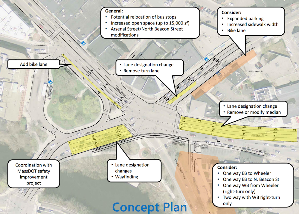
Some significant changes to traffic patterns are proposed, too. Galen can be confusing as you approach the Square, Castelli said, so the lanes is proposed to be changed. It would have four lanes – a left only, one you can make a left or go straight, one where you can go straight or right, and a right-only lane.
On Arsenal Street there is proposed to have two left turn lanes heading toward Galen Street, Castelli said, because the traffic going left in the evening commute often backs up and blocks cars going from North Beacon westbound on to Arsenal. Castelli added that MassDOT is planning improvements at the Galen Street intersection with Nonantum Road and Watertown Street to improve coordination of traffic through that area and going into the square.
A left turn lane would be removed from Mt. Auburn Street, but left turns will still be allowed, Castelli said. This would allow for the addition of a bike lane and/or parking spaces.
Other possibilities are putting a painted bike lane on Main Street approaching the intersection and moving the stop for the 70 bus either onto the Watertown Square Delta (where there big trees are located) or to the other side of the intersection on Arsenal Street.
To get an idea of how many vehicles are cutting through the neighborhood and where, VHB will be doing a license plate survey, Castelli said. She said they can also try to test some of the proposed changes.
Councilor Tony Palomba asked if the traffic studies could be expanded beyond the neighborhood near the river, and include streets like Irving north of North Beacon Street and School Street. Castelli said that would be possible, but would not likely include as many streets as in the area near the river.
Councilor Susan Falkoff said she worried about people’s license plates being stored and linked to their home address and other information. Castelli said the survey is done using fisheye lenses so that the plates are not readable by the human eye and the computer only tracks partial plates. She added that the plates are not made into a database.
Charles River Road Changes
Still up in the air is how Charles River Road will be changed. The four options for changing Charles River Road and how they would impact the neighborhood between were outlined by Castelli:
Option 1 – Make Charles River Road one way away from the Square (eastbound) to Wheeler Lane. The neighborhood between Charles River Road and North Beacon Street would not have direct access to Watertown Square. Cut through traffic would likely be eliminated in the evening.
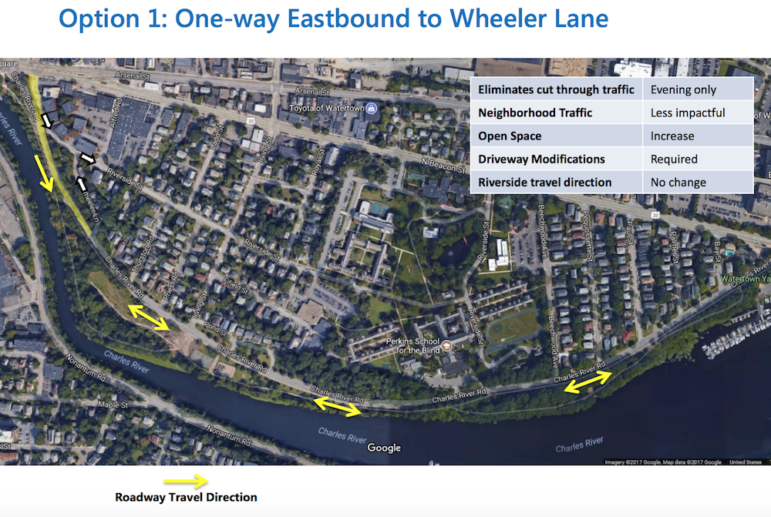
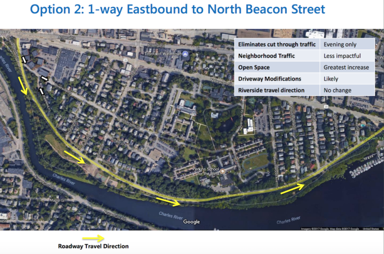
Option 2 – Make Charles River Road one way eastbound all the way from the Square to North Beacon Street (near Athenahealth). The neighborhood would have no direct access to Watertown Square. Cut through traffic would likely be eliminated in the evening.
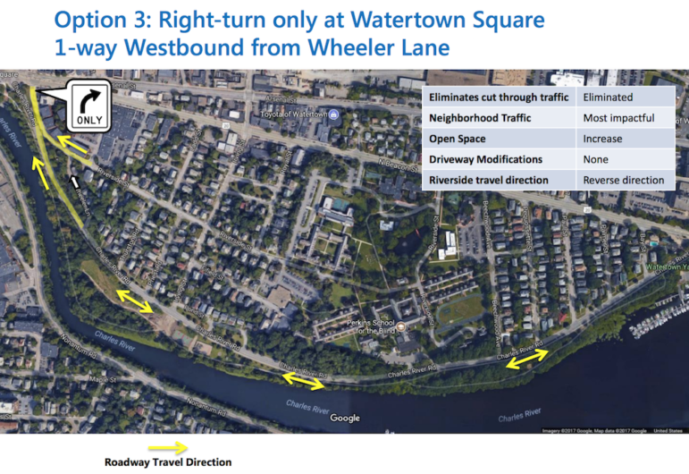
Option 3 – Make Charles River Road one way westbound from Wheeler Lane to the Square. The neighborhood would have access to Watertown Square, but would only be able to make a right turn to head eastbound on North Beacon/Arsenal Street. Cut through traffic would be eliminated in the morning and evening, so would have the greatest improvement on traffic in the neighborhood.
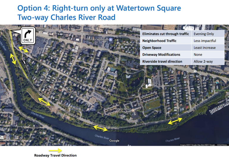
Option 4 – Keep two-way traffic on Charles River Road. The neighborhood would have access to Watertown Square, but would only on be able to make a right turn to head eastbound on North Beacon/Arsenal Street. Cut through traffic would be eliminated in the evening.
Some residents said they would like to see other options. One suggested shutting off traffic at both ends of Charles River Road. Castelli said she and her colleagues would look at all suggestions they receive.
Residents also said they would be better able to understand the proposed changes if they could see it in person. A woman suggested having walking tours to show the proposals, which Castelli said would be possible.
Open Space
Along with the changing the traffic pattern, changes to Watertown Square also include adding open space near where Charles River Road comes into the Square.
All the options would create more open space in Watertown Square where Charles River Road connects, but option 2 would create the most open space, while option 4 would make the least.
Dan Driscoll, a town resident who is the Director of Facilities at the Department of Conservation and Recreation (DCR) – which owns the land near the Charles River including the park along Charles River Road – said the project presents a great opportunity.
“We are always looking for opportunities to do road dieting and turn as much into park land,” Driscoll said.
Driscoll said he could see putting in a cycle track on Charles River Road, which puts bike lanes on a different level and separated from the roadway. He pointed to improvements made on Greenough Boulevard north of Arsenal Street as an example of what could be done.
Resident Input
Along with those who spoke, residents who went to the meeting had the opportunity to put suggestions on post-it notes on large posters of Watertown Square and the proposed changes.
People can also visit the Watertown Square Improvement website (watertownsquareimprovements.com) to submit questions and comments, get more information, view documents, and sign up to receive email updates.
To get to the form to submit questions and comments online, click here: watertownsquareimprovements.com/stay-in-touch/.
More public meetings will be held in the future to update residents on the project, Castelli said.
I believe we need greater expertise on the Town Council and Planning Board to address reconfiguration of Watertown roadways in light of increased residential units on Arsenal Street. Some of the recommendations seem extravagant when simpler and more effective solutions can be implemented.
Funneling all pass through traffic down Arsenal Street doesn’t seem like a good idea to me. Arsenal Street is already pretty busy, and it is going to get worst when the two apartment complexes currently being built – 600 units total – are rented, not to mention the development of Arsenal Yards. Let’s face it, we are an intregal part of the Boston Metro Area, pass through traffic is not going away. Charles River Road is a convient safety valve probably used mostly by residents, neighbors and local workers. Restricting it’s use will only exaberate Watertown traffic overall.
Right now Charles River Road is the only road that is not always bogged down with traffic. I take it daily to get to and from my home because it is easy the easiest and most direct route for me to take to get almost anywhere in town. If that is closed off I will be trapped in my neighborhood unless I sit in traffic just to get a mile or two.
Closing the only road that is currently the residents only saving grace is truly a bad idea and not in the towns best interests.
I don’t believe eliminating the left turn only on the north side of the square is a good idea.
If you make the other 2 lanes 1 straight and the other left you will jamb up the straight lane. If you combine one of the lanes with a left turn it will just hold up the non left hand turners in that lane. I think eliminating a lane for bike is not warranted for the future bike traffic. I believe the future bike traffic is being over estimated. Bikes should look for other ways to cross watertown square to newton. perhaps the new pedestrian bridge being built now.
A pedestrian crosswalk over Watertown Square ,It would Eliminate the walk Signals at let traffic flow easily Through the square
As a pedestrian crossing Watertown Square, at best is Difficult to maneuver.
some of the walk signals take you halfway through and you have to wait for the second walk signal to activate ,before you can finish the second part of your walk .its very dangerous crossing 18 Wheel Tractor trailers go down arsenal street through the greenlight to Galen . while women with carriages wait in the middle of the street for the second walk like to activate .A pedestrian footbridge would be very expensive ,but it could solve a lot of problems of Traffic flow through the Square
Interesting idea. I have heard it before.
I would think you would need two bridges – to get over the east-west traffic and the other to get over north-south.
I have heard the obstacles are having a bridge high enough for trucks to go under and having enough space for a landing area. It would have to have room for a disabled access ramp.
The town is studying the Square and taking comments here: watertownsquareimprovements.com/stay-in-touch/.