VHB
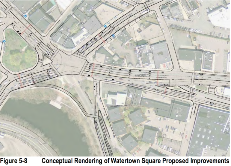
A proposed reconfiguration of Watertown Square from the Arsenal Street Corridor Study. Charles River Road would no longer connect to the Square and more left turns would be added in some areas.
Removing Charles River Road from Watertown Square, making changes to the 70 bus and improving access for bicyclists made the list of recommendations in MassDOT’s final Arsenal Street Corridor Report.
The list of recommendations remained largely the same from the draft report released by the Massachusetts Department of Transportation in June. Officials added details to their recommendation for realigning Watertown Square, including removing one of the spokes off the intersection – Charles River Road.
The benefits would be simplifying the intersection which then allows the traffic light phasing to change and make the intersection more efficient. The report acknowledges removing the road would have some complications,
“Eliminating the Charles River Road approach to the intersection may also reduce ‘cut-through’ traffic in the adjacent neighborhood. However, it was noted through the public outreach process that Alternative 7 would include further refinement, traffic analysis, and more detailed evaluation of the potential benefits and impacts on adjacent neighborhoods, specifically along North Beacon Street, Irving Street, Riverside Street, and Charles River Road,” the report reads.
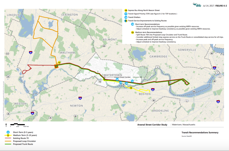
Another recommendation calls for making changes to the route of the MBTA’s 70 and 70A buses. The report calls for splitting the 70 and 70A into three routes: the existing Route 70, the overlapping “Trunk Route” portion of Routes 70 and 70A, and the North Waltham “Loop Circulator” portion of Route 70A. It also said an express bus should be considered along the main route.
The aim of the changes is to improve reliability, reduce crowding on buses and cut down on the bunching of buses – one coming right after another followed by long waits.

MassDOT
The Arsenal Street Corridor Report recommends splitting the 70/70A into three routes: the main 70 rote in red, the “trunk route” which includes the route shared by the 70 and 70A (green)and a Loop Circulator (orange), which includes the part of the 70A going in to North Waltham.
Another public transit recommendation is to create a pilot shuttle along North Beacon Street from Watertown Square to the Boston Landing Commuter Rail stop near New Balance in Brighton. While the route might be organized by the Town working with the MBTA, it will likely be funded by the Town and funds from private developers.
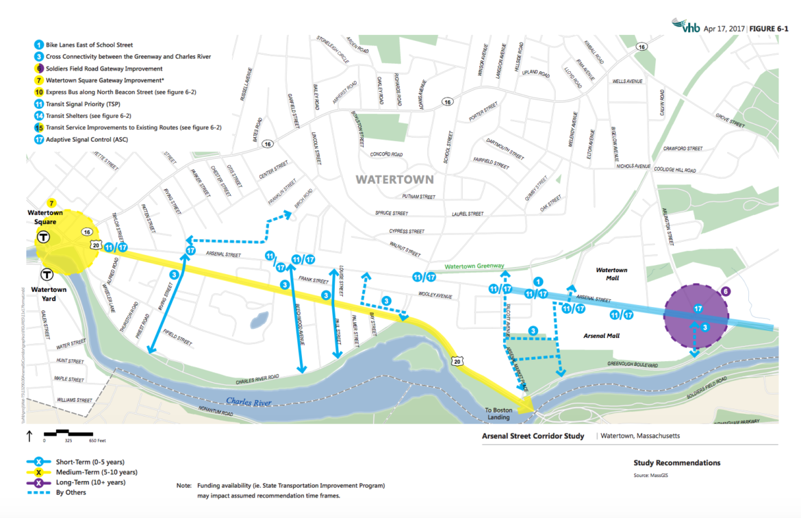
Bike accommodations also made the list, including redrawing the bike lanes on Arsenal Street, east of School Street, to provide 5-foot bike lanes. This would be done by reducing the width of vehicle travel lanes to 11 feet.

MassDOT
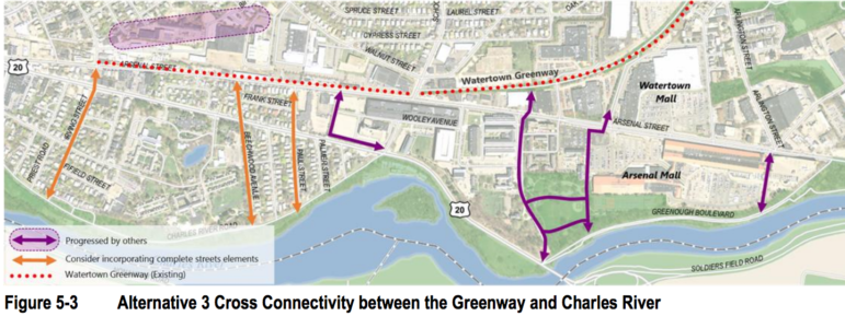
More North-South connectivity to the Charles River is recommended in the Arsenal Street Corridor Report,
The report recommends creating more north-south connections to the Charles River from Arsenal Street. That would be done by creating bicycle and pedestrian connections along roads such as Irving Street, Beechwood Avenue and Louise Street/Paul Street. These roads are not wide enough for a dedicated bike lane, so the report recommends adding shared lane markings on the streets to indicate that the road is also a bike route.
Other recommendations are:
Soldiers Field Road Gateway Improvement – which includes improvements on the Boston side of the intersection as well as proposals to re-align Coolidge Avenue so it either hits Arlington Street further north or intersects with Arsenal Street. This would require cooperation of private land owners.
Transit Signal Priority – keeping signals green for buses
Adaptive Signal Control – traffic signals that work in coordination and adjust to traffic conditions
Transit Shelters – adding shelters to eight 70/70A stops along the Arsenal Street Corridor
See the entire report here: http://www.massdot.state.ma.us/planning/Main/CurrentStudies/ArsenalStreetCorridorStudy/Documents.aspx

As I pointed out before, the second turn lane from Arsenal onto Galen St is a terrible idea. During heavy traffic it already fills up the queue waiting to go over the bridge, sometimes even blocking into the square. Doubling the amount of cars is going to lead to more frequent instances of cars blocking the square.
Our neighborhood is under siege. From the misguided realignment of Charles River Road at Watertown Square to the attempts to make our quiet side streets into thruways, none of these so-called planners is thinking about our quality of life.
The Charles River Road realignment will substantially increase cut-through traffic on our side streets. If anyone doubts that, we should close off the eastbound entrance to Charles River Road for a few days. I guarantee, you will be convinced.
Adding “shared street” markings on Paul St? Beechwood Avenue? Louise St? Between North Beacon and Charles River Road, no one would have any problem riding a bike on these streets. None are wide enough to accommodate local resident parking and “bike lanes” without limiting resident parking. What does that do to the people who live there, or visit residents? Quiet side streets with city traffic markings…stupid idea.
Do we see them adding raised crossing tables on CRR or good crosswalks on North Beacon to slow down traffic on those main arteries and make it easier to cross? That’s just too easy. Anyone who wants to travel through our side streets, either walking or biking, can do so easily now. Crossing the main arteries is the problem. Traffic speed is the problem. Too much traffic is the problem.
This neighborhood should not be treated as just an inconvenient barrier between Arsenal St and the river. Leave us alone.